Location: Freeport, Illinois | Client: EPA Region 5 and SRI | Project Date: September 2015 – August 2016
Project Images


Links and Resources
Project Description
Situation
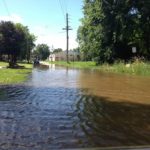
The East Side neighborhood is an environmental justice community located in the floodway of the Pecatonica River. Chronic flooding has contributed to the decline of housing quality and the loss of commercial businesses. A strained relationship between local government and neighborhood residents, partly due to the legacy of racial segregation, has stymied past attempts at neighborhood revitalization. The neighborhood is also impacted by multiple contaminated and/or vacant properties.
Solution
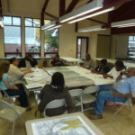
Funded by the EPA Superfund Redevelopment Initiative, the planning process started with a Needs Assessment to identify the key concerns of residents, city staff and other stakeholders. The Needs Assessment led to a training on Building Cultural Competence, which was tailored to address long-standing tensions between City staff and East Side residents and created an atmosphere that built trust and understanding. With these foundations in place, Skeo then facilitated series of workshops, focusing on (1) neighborhood revitalization, (2) green and grey infrastructure solutions for reducing flood impacts, and (3) a working session to build neighborhood resident capacity to share their message with state and federal agencies..
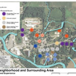
To support the discussions, Skeo developed a map set integrating resident flood experience with GIS floodplain data, green infrastructure opportunity areas and local priorities. These maps combining GIS data and personal experience helped city staff and residents forge a shared vision for moving forward. The project team constantly sought to be responsive to environmental justice concerns raised by stakeholders as conversations with the community progressed.
Outcome
The project team worked with stakeholders to produce a report that captures the community’s goals and recommendations for integrating reuse of contaminated sites with flood impact reduction and comprehensive neighborhood revitalization. Freeport Alderman Ronnie Bush remarked on the progress made with SRI support: “Over the past two years, we have made monumental progress in building strong working partnerships, addressing environmental justice issues, and laying the groundwork for significant environmental restoration of the wetlands that help absorb and clean flood water. It is now time to continue that momentum by expanding our partnerships and implementing wetland restoration projects on the East Side.”
To that end, neighborhood residents have continued to convene in preparation for meeting with FEMA to discuss opportunities to address the disproportionate impact of floodway regulations. This group is also seeking funding and opportunities to implement green infrastructure pilots that will expand the neighborhoods capacity to absorb and clean storm water.
Finally, the report will be used as a springboard for further area-wide planning work that will be conducted through an EPA Brownfields Area-wide Planning Grant to the City of Freeport. To read more about that phase of the project, please click here.